
The Harding Icefield Trail is one of the most spectacular hikes in Alaska. Ascending 1,000 feet over 4 miles is strenuous, tough and at times requires a herculean effort. What a reward though!
Every bead of sweat lost is worth it for the breathtaking sweeping views over a corner of the mammoth Harding Icefield, 700 square miles in its entirety.
You are left with a sense of feeling slightly humbled by the sheer magnitude of ice in front of you and a sense of awe that stays with you on your trip down.
This post covers everything you need to know before tackling the Harding Icefield hike, including trail conditions and different viewpoints along the route. Even a short hike is rewarded with stunning views.
OVERVIEW OF HARDING ICEFIELD AND EXIT GLACIER
An icefield is an extensive sheet of sea ice, a mass of interconnected valley glaciers. Harding Glacier, named after a US President is located in the Kenai Peninsula Mountains and Kenai Fjords National Park.
The largest icefield contained entirely in the United States, covers an astounding 700 square miles and receives over 400 inches of snow annually.
Harding Icefield is the source of 38 named glaciers, including Exit Glacier, the most accessible of the them, reached via a spur road off the Seward Highway.
Forming a 3,000 feet natural ramp for mountaineers exiting the immense Harding Glacier, the hard crevassed and fluted Exit Glacier ice, can be seen on the Glacier Overlook Trail.
HOW TO HIKE THE HARDING ICEFIELD TRAIL
STATISTICS OF HARDING ICEFIELD HIKE
From the parking lot to the start of the trail is 0.3 miles, along a flat and easy paved path. In addition to this, the stats are as follows:
- Trail Distance: 8.2 miles return
- Elevation Gain: 3,512 feet
- Difficulty: Strenuous
- Time To Complete: 6-8 hours, less if you are an active hiker
HARDING ICEFIELD TRAIL MAP

Read More: HOW TO HIKE EXIT GLACIER IN ALASKA
BE BEAR AWARE
Along the trail the vegetation is dense and passes dense pockets of salmonberries which is a favourite food for black bears. These are commonly seen along the trail and traversing Exit Glacier.
Preventative Measures include:
- Be aware of your surroundings at all times
- Make noise as you walk to avoid surprising a bear especially one with cubs
- Don’t hike alone, hike with someone else or in a group
- Carry bear spray
If you encounter a bear:
- Never get between a mother bear and her cubs
- Give a bear plenty of room and slowly back away
- Put plenty of space between you
PARKING FOR THE TRAIL
The trail for Exit Glacier and Harding Icefield begin next to the nature center located in the parking area, at the end of Exit Glacier Road (Herman Leirer Road).
From Anchorage, drive south on the Seward Highway to the outskirts of Seward. At about Mile 3 turn right onto Herman Leirer Road, also called “Exit Glacier Road.” Be sure to pull into the layby en route, for your first incredible roadside view of Exit Glacier.
Follow the road for 8.4 miles to a large free parking area for the nature center. There are separate spots for RV’s, but if it is busy, cars do “double up” in the spaces.
Top Tip: Arrive early morning or late afternoon to avoid not being able to park.
On arrival, pop into the nature center to check up to date trail conditions. Rangers are on hand if you need advice re trail elevation gain. You may want to make use of the restrooms, located to the side of the building, before starting this day hike.
SHUTTLE SERVICES FROM DOWNTOWN SEWARD
If you don’t have your own transport don’t worry, you can take a shuttle from downtown to the nature center.
- Exit Glacier Shuttle: Offer one-hour shuttles for $15 return. An early 8.30am shuttle runs on Friday, Saturday & Sunday. Last shuttle leaves the nature center at 5pm. Be sure to schedule your pick-up. The shuttle also partners with Exit Glacier Guides to offer interpretive hikes of the park.
TRAIL CONDITIONS OF HARDING ICEFIELD HIKE
Don’t be lulled into a false sense of security walking the 0.3 miles from the center to the start of the trail. From the very beginning you start climbing and basically don’t stop as you gain 3,000 feet elevation over 4 miles.
The bonus however of this strenuous climb is stunning views. There are three main points along the trail:
- Marmot Meadows: Total ascent 1,572 feet | 1.4 miles
- Bottom Of The Cliffs: Total ascent 1,788 feet | 1.8 miles
- Top Of The Cliffs: Total ascent 2,452 feet | 2.4 miles
- Trail End (Harding Icefield): Total ascent 3,512 feet | 4.10 miles
Although the Harding icefield trail elevation makes for a strenuous climb, the trail is easy to follow.
BEST TIME TO HIKE THE EXIT GLACIER HARDING ICEFIELD HIKE
The best time to hike the Harding Icefield Trail is during the summer months, from July through mid-September.
Even through early July the upper portion of the trail is often covered with snow with possible avalanche danger. Summer months provide long daylight hours and warmer temperatures.
You should be prepared for unpredictable weather including fog, rain, high winds, temperature changes and extreme sunlight.
We hiked the trail on the 29th June and while we enjoyed blue cloudless skies, the high temperatures made the climb hard going.
When we reached Top of the Cliffs Overlook, a sign advised of an avalanche further up the trail with only those with avalanche experience advised to continue.
Top Tip: The weather in downtown Seward can be very different to the weather at Exit Glacier. Even if it is raining, drive up to the nature center and check weather conditions at the trail.
STARTING POINT OF HARDING TRAIL

From Exit Glacier Nature Center, turn left past the trailhead map and follow the accessible Glacier View Loop Trail. The path is well maintained and flat. Just before the sign for Harding Icefield, the trail becomes the Glacier Overlook Trail.
At the trail start, there is a trail map, a place to sign in and boot cleaner. Okay you are ready to experience an epic day of hiking.
HIKING TO MARMOT MEADOWS VIEWPOINT
After turning right at the sign, the trail starts on the valley floor and winds its way through cottonwood and alder forests.
You will cross a small bridge over a stream and start to ascend the trail along switchbacks. At this point you are half way to Marmot Meadows! Your view will be blocked by the trees and you have to hike for nearly a mile before a clearing provides your first view.

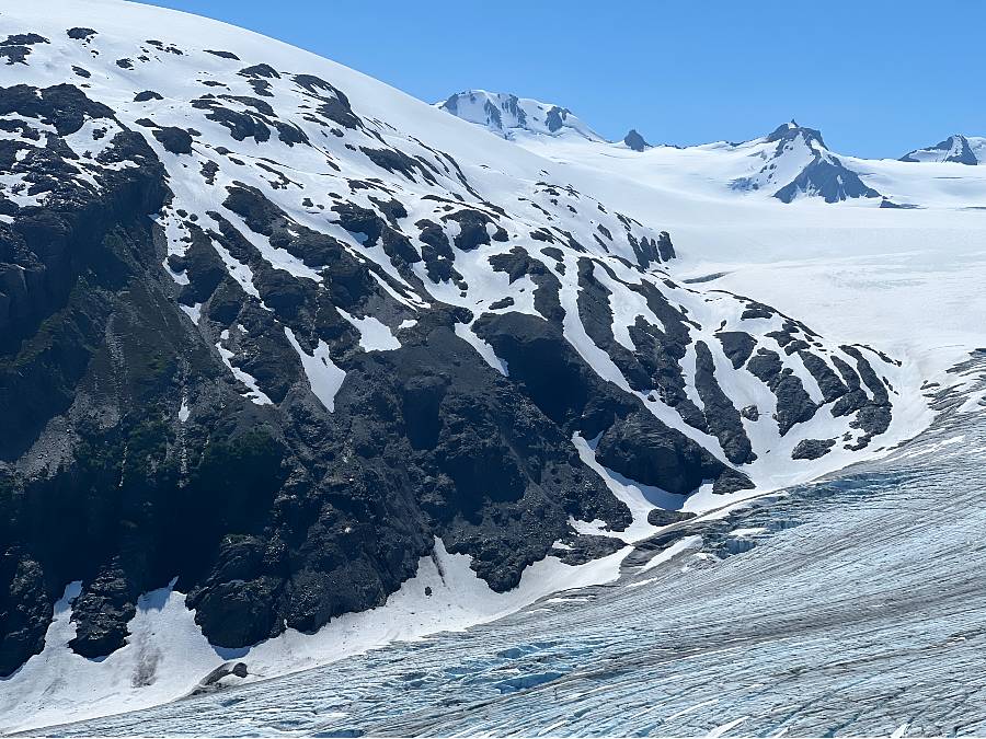
The trail starts to become rockier and steep, narrowing between boulders. You will now get your first view of Exit Glacier as the trees thin.

You can see how far you have already climbed from the car park, and don’t have far to go.
Marmot Meadows makes a great rest stop or a place to turn around. Veer slightly off the main path to a small clearing and your first great viewpoint. Sit and take in the stunning views across Exit Glacier.

A small thin trail leads from here to the side of Exit glacier and is the path used by those on an Ice Trek Tour.
HIKING TO TOP OF THE CLIFFS OVERLOOK
Continue straight past the Marmot Meadows signpost and follow the trail towards the Top of the Cliffs Viewpoint. This portion of the hike passes through heather filled meadows, ultimately climbing well above tree line to a breath-taking view of the Icefield.

After roughly 0.5 mile you will reach the “Bottom of the Cliffs” and the start of the switchbacks up the cliffs. This part of the trail is steep and arduous as it feels like you are climbing a ladder that goes on and on as you gain height.


The views keep you going through the relentless climb. Vegetation is lower and scattered, the green grass dotted with flowering wildflowers.

But the views along the way of Exit Glacier’s rolling crevasses will keep your spirits up.

After about 0.5 mile the trail turns a corner and even though there’s no formal marker, it is obvious you have reached Top of the Cliffs.

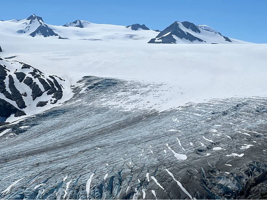
Your payoff for all that climbing is spectacular views of the end of Harding Icefield and the beginning of Exit Glacier! The mountain peaks protruding from the surface of the icefield are called nunataks.


HIKING TO THE END OF TRAIL AND HARDING ICEFIELD
If you continue to the trail end, you are still climbing but not as steeply. Your climb is interspersed with flatter sections and downhill stretches. In parts you may need to traverse across patches of snow.
The views improve further as you progress. At mile 3.9 you reach an emergency shelter which can be used in case of inclement weather and is not for overnight use. At this point the elevation gain is 3,459 feet.
The end of the trail is in sight! At mile 4.1 and at an elevation of 3,512 feet, you have reached Harding Icefield.

Enjoy the sweeping views across the immense expanse of ice!
TAKING A GUIDED TOUR TO HARDING GLACIER
If you don’t want to hike on your own and would prefer a guide, you have a few options:
- Exit Glacier Guides: Offers trail hikes from late June through to 9th September. They also have a Glacier Ski Plane Adventure 5 hour tour, with a landing in a high glacial bowl in the upper portion of the ice field.
- Seward Wilderness Collective: A tour leaves early morning for a full day hike.
WHERE TO STAY NEAR EXIT GLACIER
If you are planning to camp at Exit Glacier you have two choices:
- A 12-site tent campground is located about 0.25 of a mile before the nature center. Sites are available on a first-come, first-served basis and free. During July & August, sites fill up by early evening.
- Set up camp along the Harding Icefield Trail corridor. You must follow the principles of leave no trace, limit your group size, avoid damaging fragile fauna, set up camp at least 1/8 mile from the trail on bare rock or snow, in a spot out of site of the trail.
RV and tent camping is also available in Seward along the Resurrection Bay waterfront. Plus there are numerous options in Seward for those looking for hotels, lodges etc.
WHAT TO PACK AND BRING WITH YOU
- At least 2 liters of water per person
- Sunscreen
- Sunglasses – otherwise you will be struggling with sun reflecting off the ice & snow
- Sun hat – most of the trail is open to the elements
- Bear spray
- Plenty of nourishing food & snacks & an odor-free zipped bag to contain your rubbish.
- Sturdy footwear
- Warm clothes you can wear in layers
- Rain gear including a jacket as weather is unpredictable
- Hiking poles if you usually use them
OTHER QUESTIONS
How Long Does It Take To Hike Harding Icefield?
Depending how far you follow the trail, you can walk to the end of the trail and back in 4-6, although the official estimate is 6-8 hours. Just take your time and enjoy the epic scenery.
Is The Harding Icefield Worth The Time?
Definitely, especially in clear weather.
How Difficult Is The Harding Icefield Trail?
The hike is classed as strenuous and we agree! Just take your time and hike as far as you can before turning around.
Will I see Any Wildlife Along The Trail?
Common sightings include marmots, mountain goats and black bears.
Where Can I Check Harding Icefield Trail Weather Conditions?
Check on trail conditions before starting out. The nature center rangers will have up-to-date information. The upper portion of the trail is often covered with snow through early July and there may be avalanche danger.
Can I hike the trail in winter?
The Harding ice field trail is considered a mountaineering route during winter due to it being covered in snow. Plus Exit Glacier road is closed to cars during the winter.
Is There A Fee For Parking And Entering The National Park?
No, both are free.
How Many Glaciers Spill From The Icefield?
Harding Icefield feeds nearly 40 glaciers, including Exit Glacier.
Read all our articles about this region in our Southcentral Alaska Guide
Do you feel ready to explore Harding Icefield? If you have any personal tips or questions about the Harding Icefield hike please let us know in the comment section below.

This post may contain affiliate links, which means we may receive a small commission, at no additional cost to you, if you make a purchase through this link. This income goes towards the sites running costs and enables us to provide our readers with free content. Read our Disclosure.