Dear Reader, GlobalGadding has no sponsored content, just genuine advice. Some links may be affiliate links at no extra cost to you. See our Disclosure Policy for more information.
The Vereda da Ponta de São Lourenço hike (also known as the PR8 Madeira trail) is one of the best hikes in Madeira. A rugged, windswept coastal trail at the easternmost point of the island where you feel utterly exposed to sky, sea, and elemental rock.
If you only do one Madeira hike that isn’t a levada walk, this is the one.
We walked this trail on a perfect mid‑September morning — bright blue skies, warm sun, and that clear horizon that seems to stretch forever.
From the start, the colours are jaw‑dropping: intense blues of the Atlantic, rust and ochre cliffs, golden grasses, and stark volcanic rock.
There’s a rawness here that feels entirely different to the lush interior levada walks — this is coastal, elemental, and utterly unforgettable.
In this guide to how to hike PR8, I’ll walk you through everything you need to plan your hike. Quick facts, how to get there, what to expect on the trail, where the best viewpoints are, and the practical tips we used to make our day smooth and relaxing.
📊 Quick Stats — Vereda da Ponta de São Lourenço (PR8)
| Detail | Info |
|---|---|
| Trail Name | Vereda da Ponta de São Lourenço (PR8) |
| Location | Eastern tip of Madeira Island |
| Distance | ~7–8 km round trip |
| Total Climb | ~500 m (est.) |
| Highest Point | Pico do Furado (~170 m) |
| Duration | 2.5–4 hrs (with breaks) |
| Difficulty | Eas to Moderate |
| Trailhead | Baía d’Abra (main parking area) |
| Hiking Fee | ~€4.50 per adult (non‑resident; subject to change) |
💡 Since 1 January 2026, access to Madeira’s 42 official trails requires an online reservation — it’s mandatory, not optional. Bookings are handled through the SIMplifica platform, so we recommend sorting your slot in advance (especially for popular routes).
🌍 What Ponta de São Lourenço Actually Is — From Someone Who’s Walked It
Ponta de São Lourenço isn’t just a name on a map — it’s one of those places that feels like the edge of the world.
This narrow, finger‑like volcanic peninsula sticks out from the easternmost tip of Madeira, shaped by ancient lava flows and sculpted over millennia by powerful Atlantic winds.
When you’re on the trail, the bare rock, rust‑coloured earth, and wide ocean views make you feel as if you’re walking the spine of the island itself.
The name comes from Gonçalo Zarco, one of the early Portuguese explorers who helped chart Madeira — but the landscape here feels far older than any human history.
The land is mainly basalt, streaked with bands of limestone that have been wind‑eroded into weird and wonderful shapes.
It’s the kind of place where you can see the geology at work: sharp ridges, strange bulbs of rock, and ancient layers that speak of fire and sea.

On clear days — like the bright mid‑September morning we did the hike — you can make out the Desertas Islands to the south, tiny and remote against the blue sea.
To the north, Porto Santo Island sits on the horizon, just visible above the sparkling Atlantic. The peninsula also has two little satellite islets — Desembarcadouro and São Lourenço Point Isle — adding to the dramatic coastal skyline.
Despite its ruggedness, this stretch of land is ecologically important. It’s a partial nature reserve, home to a variety of endemic plants that cling to the salty breeze and sparse soil.
Birdlife is abundant too — we spotted shearwaters wheeling overhead and heard calls from cliff‑nesting seabirds that are part of Madeira’s protected avian community.
Ponta de São Lourenço is part of the São Lourenço Nature Reserve, a protected area managed for its unique geology and endemic flora — which you can learn more about on the official Instituto da Conservação da Natureza e das Florestas site:
🚗 How to Get to the PR8 Trailhead (Baía d’Abra)
Driving to Ponta de São Lourenço is straightforward, but the road feels like a transition from cultivated valleys and towns to something wilder and more elemental.
From Funchal, head east on the ER101 toward Machico. After you pass Machico and start edging closer to the eastern coast, you’ll see signs for Ponta de São Lourenço / Baía d’Abra.
Follow these until the road just ends — literally — in a small turnaround circle. That’s your cue: you’ve arrived at the PR8 trailhead.
On clear mornings like ours, you can see the light play across the water from the car window, and the anticipation builds as you pull into the parking area.
The trail starts right from this turnaround point — no winding forest approach, no signage maze — just open air and the ocean horizon ahead.
If you’re relying on public transport, be aware that buses run only occasionally from Machico or Caniçal, and they don’t always align with ideal hiking times (like sunrise or early morning).
For most visitors, especially if you want flexibility and to beat the crowds, a car is the easiest option.
🕑 Transit Times to the Trailhead
| From | Drive Time |
|---|---|
| Funchal | ~35 min |
| Machico | ~15 min |
| Caniçal | ~10min |
| Santana | ~30 min |
| Porto Moniz | ~75 min |
🅿️ Parking at Ponta de São Lourenço
The car park at the end of the road above Baía d’Abra is free of charge, but it fills up surprisingly quickly. On crisp, clear days (which are common in September through November), you’ll see hikers arriving as early as 8 am.
Spaces are well‑marked and spread to the left and right of the trailhead. Since the hike is popular and the lot isn’t huge, aim to arrive before 8.30 am if you want your pick of spots — especially in peak seasons like spring and autumn.
There’s no paid or staffed parking here — just open spaces and that sense of being on your own at the end of the road.
From the car park, the trail begins immediately, marked by an information board and a clear path that drops gently down toward the first bridge crossing.
🥾 Hiking the Vereda da Ponta de São Lourenço – Detailed Route Breakdown

🌅 Trail Start — From Baía d’Abra Parking to Coastal Ridge
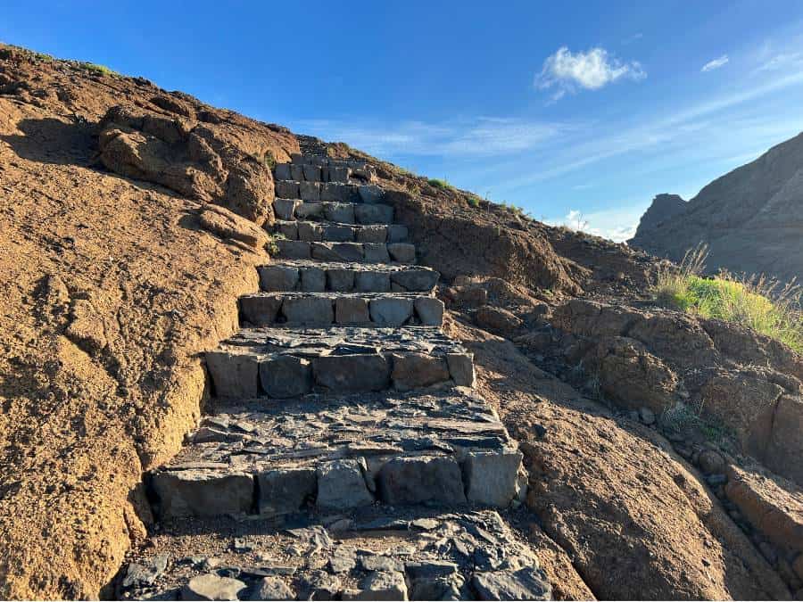
From the trailhead parking area, the Vereda da Ponta de São Lourenço path immediately dips downhill on rust‑coloured stone steps, crosses a wooden bridge, and opens up into that vast, elemental space the peninsula is known for.
Right away, you feel the difference compared to other Madeira walks: there’s very little shade, an ongoing ocean soundtrack, and wide vistas that stretch in every direction.

The path is well defined, but on sunny days — like the clear, warm mid‑September morning we did this — you’ll want to be moving by early morning to dodge heat and trail crowds.
Pro Tip: Start early — not just for cooler temps, but because the light on the cliffs is absolutely incredible around sunrise and soft enough to photograph without harsh shadows.
🏖️ Optional Detour — Praia de São Lourenço Bay
About 10–15 minutes in, you’ll see an optional right‑hand turnoff that leads you down toward Praia de São Lourenço, a tucked‑away, peaceful bay nestled in the cliffs.
We personally skipped this detour, not because it’s not lovely, but because the climb back up is steep and we wanted to conserve our energy for the higher viewpoints and Pico do Furado.
If you enjoy quiet coves and gentler terrain, though, it’s definitely worth the side trip — especially on a sunny or slightly windy day when this little beach feels like a calm mini‑oasis.
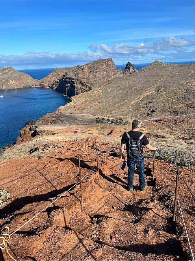
📸 Miradouro Ponta de São Lourenço — First Epic Viewpoint
As you rejoin the main trail and climb, the cliffs begin to rise sharply, and soon you’ll reach the Miradouro Ponta de São Lourenço viewpoint — one of the first jaw‑dropping moments on this coastal ridge walk.

The interplay of deep Atlantic blue, ochre and rust cliffs, and those greenish‑black volcanic layers practically beg you to stop and stare.


There are low wire fences along the edges here, so stay behind them to protect the fragile cliffside flora and for your own safety.
This is one of those spots where the camera rarely rests in your hand.
🌿 Midway Views and Bridge Crossing
The trail continues with gentle rises and falls, unveiling more ocean panoramas at almost every twist.
Shortly after the initial viewpoint, you’ll cross another small wooden bridge and begin to notice the textures shifting: rugged volcanic stones, sparse coastal scrub, and wind‑blown grasses.

This is where the remote quality of the PR8 trail really settles in. There were moments when we simply stopped to breathe, look around, and let the scale of the peninsula — and the sea — sink in.

This stretch truly shows why Ponta de São Lourenço is one of Madeira’s most celebrated hikes.
⚠️ Safety & Crowd Tips
- Wind & Exposure: The narrow ridge sections can feel exposed, especially when windy. Take your time and watch your footing.
- Crowds Peak Midday: Expect more people between 10:00–14:00, especially in summer and holiday periods.
- Best Light: Early mornings offer softer shadows and cooler temperatures.
- Sun & Shade: There’s almost no shade — bring sun protection and plenty of water.
☕ Stop: Casa do Sardinha — Midpoint Rest Stop
Roughly around the 2 km mark, the path descends more steeply toward Casa do Sardinha, a shaded resting point with palm trees and — when open — a small snack bar and ranger station.
When we visited, the snack bar wasn’t serving, so sadly no ice creams or cold drinks! That said, it’s still a perfect spot to pause, sit under shade, and enjoy a quick break with your packed snacks before tackling the next climb.
If you’re itching to change the scenery, Praia do Sardinha , a small nearby beach, is worth a quick wander if your timing and energy allow.

In summer months, there are even boat tours that leave from here to the lighthouse and back — a lovely alternative way to appreciate the coast.
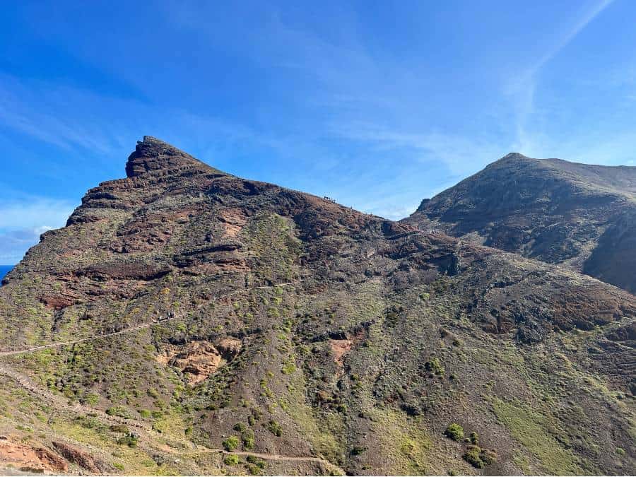
⛰️ Final Climb — Up to Pico do Furado
After Casa do Sardinha, the landscape transitions again as the trail climbs toward a narrow plateau and then steeply up to Pico do Furado, the highest accessible point along the peninsular ridge.

This part of the PR8 Vereda da Ponta de São Lourenço hike is where the wind really starts to make its presence felt.
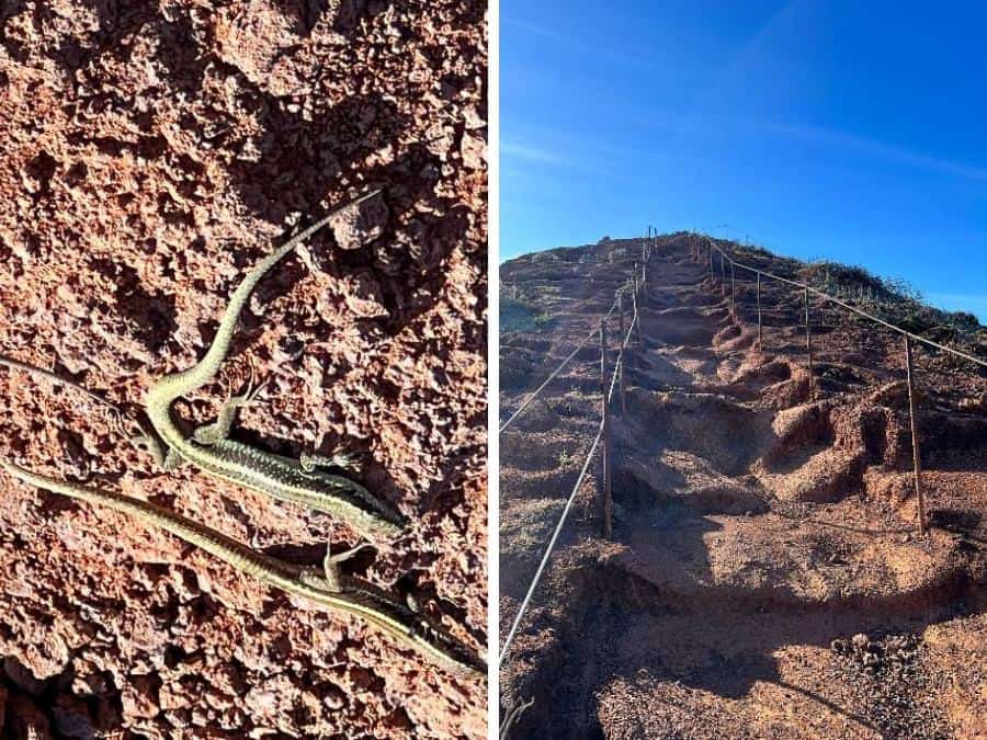
Uneven stone steps and narrow ledges mean you’ll want to take your time. Some guides mention closures near the summit, but on our walk we saw no official signs — just wide, open sky and layers of ocean below.
We saw speedy little lizards were everywhere on the final climb — sunbathing and darting across the trail.
At the top, the payoff is spectacular: pounding waves crashing against ancient cliff faces, a horizon that doesn’t end, and if you’re lucky — like we were — distant islands shimmering on the far edge of your sight.
The spired tip of Ponta do Furado shows exactly how the sea has worked on this landscape over centuries, carving unique shapes into the rock.

🔁 Return Hike — Same Route Back
Since this is an out‑and‑back trail, you’ll retrace your steps the way you came.
Oddly enough, the views somehow feel different in reverse — maybe because you’re no longer looking for the next scenic wall, but rather appreciating what you’ve already seen with a fresh perspective.
The climb back from Casa do Sardinha does feel longer on the way out, but there’s something rewarding about it — like revisiting favourite moments with the wind at your back instead of in your face.

We found ourselves stopping for photos just as much on the return, and that’s really the spirit of this hike: every angle seems to offer something worth remembering.
🧳 Tips for Your Vereda da Ponta de São Lourenço Hike
- Start early to avoid crowds and heat.
- Bring 2+ liters of water per person.
- Sunscreen, hat, and sunglasses are essential — shade is rare.
- Good hiking shoes make uneven volcanic terrain easier.
- Check weather forecasts — winds can pick up abruptly.
🏁 Is Vereda da Ponta de São Lourenço Worth It?
Absolutely. The São Lourenço peninsula walk delivers constant drama: volcanic geology, endless ocean views, rugged cliffs, and subtle ecosystem nuances you won’t find elsewhere on Madeira.
It’s sensory in every direction and one of the island’s most memorable walks.
Whether you’re a landscape lover, a casual hiker seeking views, or someone who loves a good coastal trail, this one sticks with you long after you’re back home.
🏖️ Ready to Cool Off? Discover Madeira’s Best Beaches
After hiking the São Lourenço peninsula, head to one of Madeira’s most beautiful beaches to swim, sunbathe, or just a well-earned break. It’s the perfect post-hike reward.
More Madeira Adventures
We have several other articles to help with your planning:
- Driving in Madeira – a guide for first timers
- Cable Cars in Madeira for a thrilling ride
- Visit Ponta do Garajau Madeira
- Renting a car in Madeira
- Best Towns in madeira
- Ponta Do Sol Madeira
- Madeira Hidden Gems

Meet Angela
Angela is the founder and writer of GlobalGadding, a travel resource for road-trip lovers and independent travellers.
She’s explored 40+ countries, and road tripped across New Zealand, Alaska, Australia, Canada, UK, Sri Lanka, USA, Namibia, and Europe.
She creates detailed, easy-to-follow itineraries that take the stress out of planning. Her mission is to help readers craft their own self-drive trips.